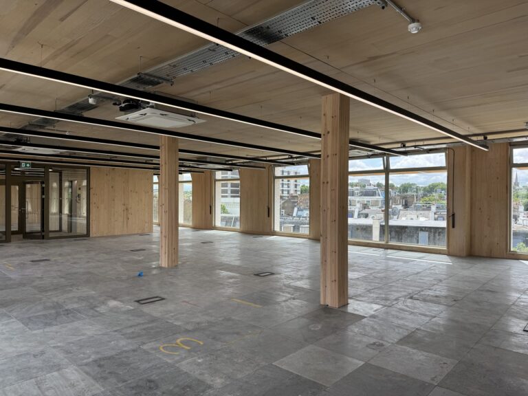
A key contributor to this effort is Woodknowledge Wales (WKW), whose deep commitment to building a sustainable, low-carbon future has shaped both the content and direction of this Yearbook. Led by Sarah Lawton, an editor and communicator working to connect the timber industry with the wider climate, land-use and design agenda, the WKW team has played a central role in curating the insights, case studies, and technical contributions you'll find in these pages.
Heddwyn Bye explains how terrestrial LiDAR scanning offers a breakthrough in assessing timber quality and carbon stocks in complex UK woodlands—unlocking economic potential and supporting climate-smart, precision forestry.
Across the UK, hundreds of thousands of hectares of small, irregular and underutilised woodlands are overlooked by traditional forest management systems. Their complex structure and non-uniform species mix make it difficult to assess timber value or carbon potential using standard inventory tools. But what if there were a way to peer inside the tangled canopy and see, with precision, what each tree could really offer?
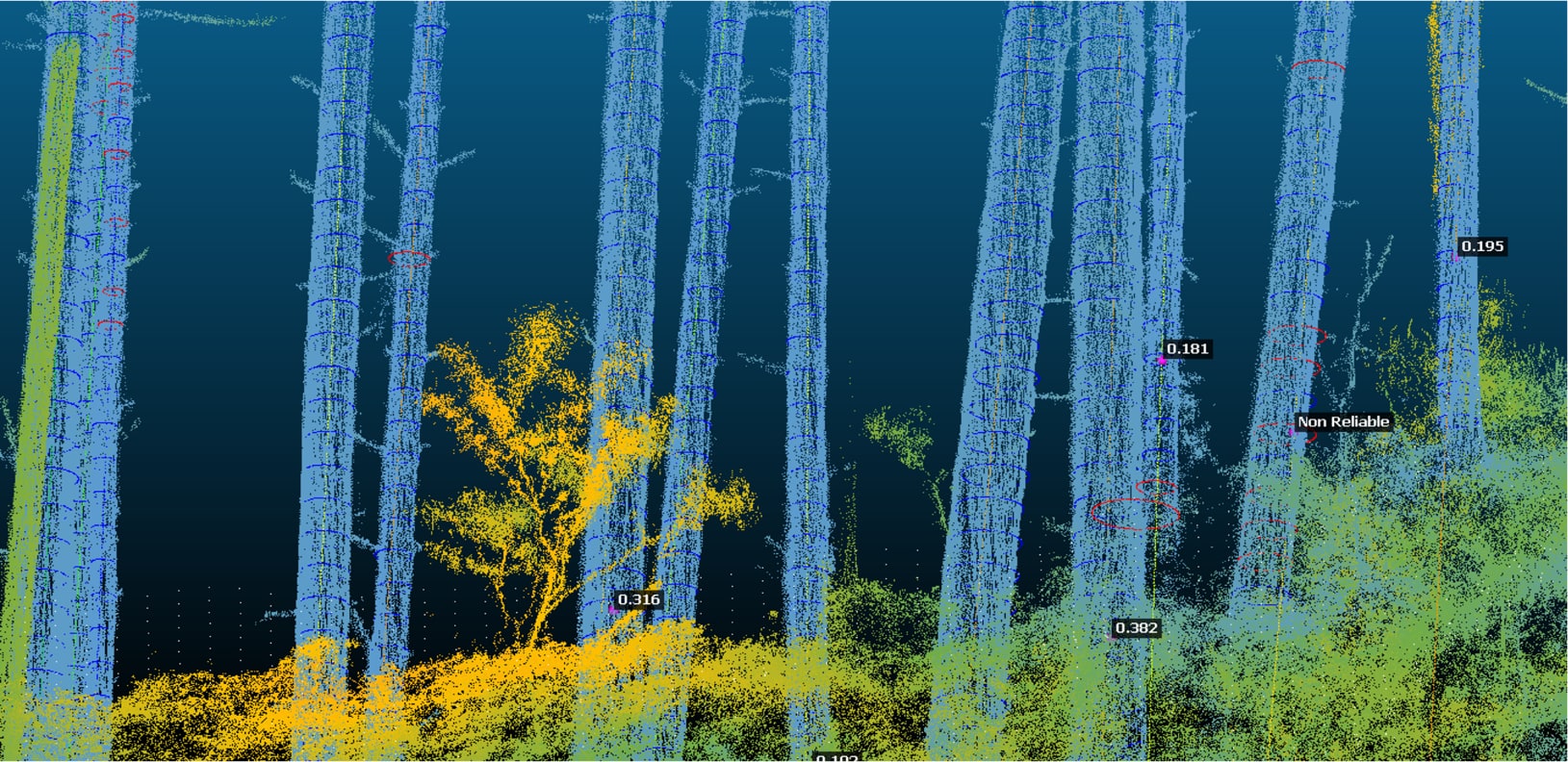
Figure 1: LiDAR point cloud of forest showing fitted diameter sections and stem diameters (labels) processed using the 3DFin plugin.
A growing body of research suggests there is. At Bangor University, I’ve been exploring how terrestrial laser scanning (TLS)—a tripod-mounted form of LiDAR (Light Detection and Ranging)—can measure the structure of standing trees with millimetre accuracy. Our findings show that TLS doesn’t just replicate conventional forest inventory metrics like DBH (diameter at breast height) or tree height—it is able to provide deeper insights into timber quality and carbon storage potential.
This technology could be transformational for complex woodlands: the unmanaged alder and hazel groves, the overstood coppice, the farm woodlands that dot the Welsh landscape. These are the forests that rarely see a forester’s tape measure, let alone a management plan. TLS gives us a way to measure their value—accurately, efficiently, and, crucially, before a single tree is felled.
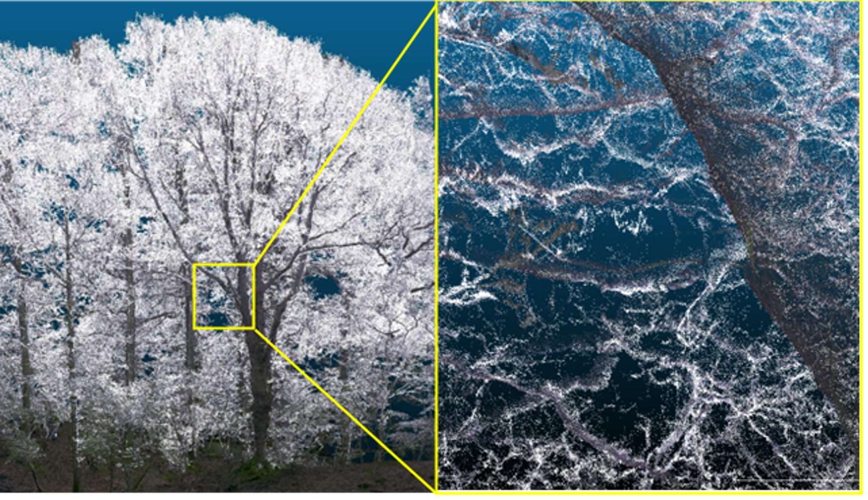
Figure 2: TLS point cloud of a stand of oak trees, colourised. Left: the whole point cloud is shown. Inset Panel: a zoomed-in section in which the individual points making up the model of the tree can be seen. Processing these point clouds enables measurement of objects within them, and subsequently, the measurement of variables of interest for forest inventory applications.
From scan to sawlog: predicting timber yield in 3D
Traditional forest surveys rely on manual tools and a great deal of subjective visual assessments by a professional. Measuring the structural quality of a tree—its sweep, lean, taper, or stem defects—is a slow and imprecise process. For small-scale or inaccessible sites, it’s often simply not done.
TLS changes this. It works by firing hundreds of thousands of laser pulses per second, creating a dense 3D ‘point cloud’ of the forest. From this cloud, we can extract not just DBH and height, but also detailed shape parameters: how straight or curved a tree is, how much it leans, how its trunk narrows towards the top.
In our study, we surveyed 55 trees across eight Welsh woodland plots of varying complexity—from well-managed Douglas fir plantations to dense, naturally regenerated broadleaf stands. Using a Leica BLK360 scanner, we
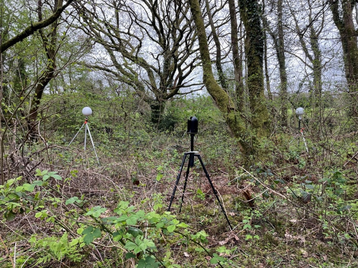
Figure 3: The Leica BLK360 device used to scan a plot (central) and two of the three reference spheres used to act as tie-points to assist in alignment of individual scans.
captured highly detailed scans of each plot, later segmented and analysed using open-source tools like CloudCompare and RStudio. A custom-built algorithm then applied UK-specific sawlog grading rules to the measurements, estimating what proportion of each tree’s stem could be classed as green or red sawlog—and calculating the associated market value. The results were promising. TLS-derived measurements of DBH and taper showed high correlation with manual methods, while also offering a level of detail—and consistency— that manual surveys struggle to match. For each tree, we could estimate not only total timber volume, but the likely grade, length, and commercial value of future sawlogs.
Precision forestry for carbon accounting
Better timber data is only half the story. When it comes to forestry’s role in climate mitigation, accurate carbon accounting is essential. Current approaches rely heavily on allometric equations—broad statistical estimates based on simple measurements like DBH and height. These are useful at scale but often fail to capture the structural quirks of broadleaf trees or small branches, leading to underestimates of biomass and stored carbon.
TLS allows us to move beyond estimation. By directly measuring the tree’s volume in 3D—including its taper, sweep, and branching structure—we can derive more accurate calculations of aboveground biomass. In one comparison, TLS-derived volumes were found to be nearly double those predicted by standard equations. This has profound implications for landowners participating in woodland carbon schemes or aiming to quantify the climate benefit of restoration efforts.
For example, a neglected farm woodland that’s too complex for traditional inventory may still hold significant carbon value. TLS provides a method to evidence that, bringing these woodlands into scope for management, funding, and long-term stewardship.
Why isn’t everyone using it yet?
Despite its promise, TLS is not yet widely used in UK forestry. There are several reasons. First, the scanners themselves are expensive and sensitive to weather—rain or strong wind can distort point clouds. Second, the data they generate is complex and unwieldy. Processing a single plot’s scan requires specialised software and expertise.
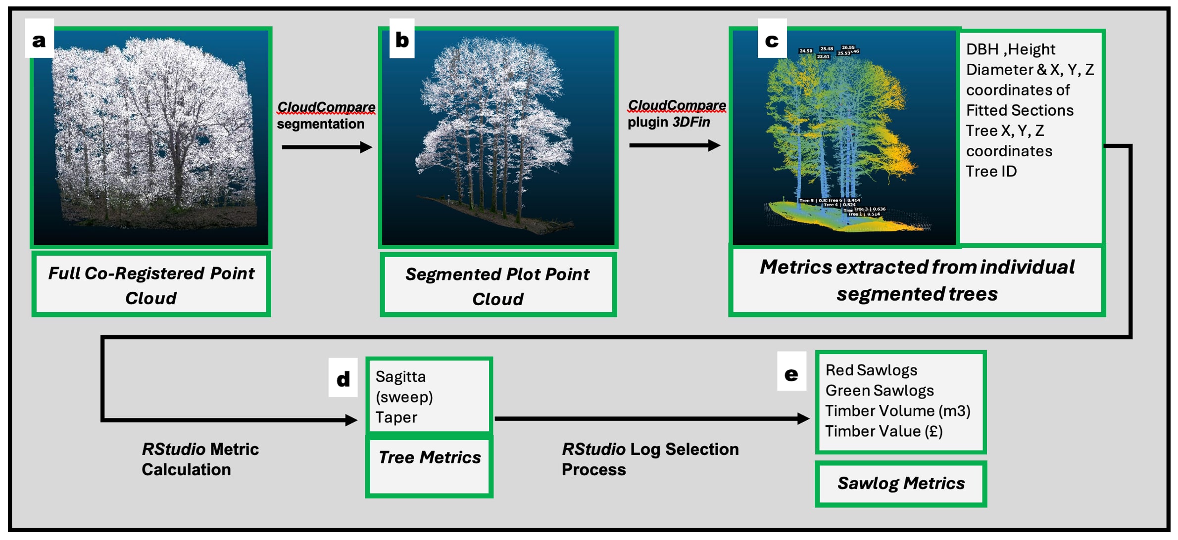
In our study, we developed a multi-step data processing pipeline using open tools and custom R scripts. This approach worked—but it’s not realistic for routine operational use.
Figure 4: Method used for the calculation of metrics from LiDAR point cloud of a forest. Each step describes a separate stage in the semi-automatic data processing method. These steps are explained further in the text below.
What’s needed next is automation: software that can process TLS data in the field, classify trees, assess their form, and generate usable inventory outputs with minimal human input.
Some progress is being made on this front. Researchers have demonstrated helmet-mounted laser scanners with real-time processing capability. But these tools are not yet widely available, and full automation remains a work in progress.
A new era for small woodlands
TLS will not replace conventional forest inventory overnight. But it could expand what’s possible—especially in the UK’s mosaic of small, complex woodlands. These are the areas where conventional approaches struggle but where the need for better management is acute. Better data leads to better decisions. And with the right tools, we can see beyond the trees to understand the full value of our woodlands— economically, ecologically, and climatically.
By embracing TLS, we can bring overlooked forests into active management, increase the proportion of timber going into high-value, long-lived products, and deliver more robust carbon outcomes. In a world racing toward net-zero, that’s a shift worth scanning for. n
To provide the best experiences, we use technologies like cookies to store and/or access device information. Consenting to these technologies will allow us to process data such as browsing behavior or unique IDs on this site. Not consenting or withdrawing consent, may adversely affect certain features and functions.
Functional
Always active
The technical storage or access is strictly necessary for the legitimate purpose of enabling the use of a specific service explicitly requested by the subscriber or user, or for the sole purpose of carrying out the transmission of a communication over an electronic communications network.
Preferences
The technical storage or access is necessary for the legitimate purpose of storing preferences that are not requested by the subscriber or user.
Statistics
The technical storage or access that is used exclusively for statistical purposes.The technical storage or access that is used exclusively for anonymous statistical purposes. Without a subpoena, voluntary compliance on the part of your Internet Service Provider, or additional records from a third party, information stored or retrieved for this purpose alone cannot usually be used to identify you.
Marketing
The technical storage or access is required to create user profiles to send advertising, or to track the user on a website or across several websites for similar marketing purposes.